Corsica is the fourth-largest island in the Mediterranean — 8,722 km², 1,047 km of coastline, and one of the most dramatic sailing landscapes in the western basin. French since 1768 (ceded by the Republic of Genoa one year before Napoleon was born there), it feels nothing like mainland France. The interior is mountainous and wild — Monte Cinto reaches 2,706 metres — and the coastline ranges from white sand lagoons in the north to sheer granite cliffs in the south. The Bocche di Bonifacio, separating Corsica from Sardinia by just 7 miles, is one of the most wind-accelerated passages in the Mediterranean and requires serious weather awareness. For sailors, Corsica is best approached from the south — start at Bonifacio and work north, or run a circuit combining both islands in the same trip.
✈️ Airports & Getting There
| Airport | Location | Best for |
| Figari Sud-Corse (FSC) | 25 km from Bonifacio | South Corsica — Bonifacio, Lavezzi, Porto Vecchio. Best airport for the south coast. |
| Ajaccio Napoléon Bonaparte (AJA) | West coast, central | West coast sailing. Ajaccio marina, Golfe de Girolata. |
| Bastia Poretta (BIA) | NE coast | North Corsica — Bastia, Saint-Florent, Calvi area. |
| Calvi Sainte-Catherine (CLY) | NW coast | Northwest coast. Calvi, Balagne region. |
Ferry connections to Corsica from mainland France (Nice, Toulon, Marseille) and Italy (Livorno, Genova, Civitavecchia) run year-round. Santa Teresa Gallura (Sardinia) to Bonifacio ferry: 50 minutes, frequent in season.
️ Weather & Sailing Season
The sailing season runs May to October. Corsica is not a beginner’s destination — the wind systems are powerful and the coastline has limited shelter in many areas.
| Wind | Direction | Season | Character |
| Libeccio (Maestrale) | NW / W | Year-round, peaks summer | Dominant wind. Funnels through the Bocche di Bonifacio. Can reach F7–8 rapidly. West coast most exposed. |
| Tramontane | N / NW | Spring, autumn | Cold, gusty. Strong in the Bocche. Can blow 6–8 Beaufort for several days. |
| Ponente | W / SW | Summer afternoons | Thermal. Builds from midday on the south and west coasts. 15–25 knots typical. |
| Scirocco | SE / S | Spring, autumn | Hot and humid from Africa. Uncomfortable swell on south-facing coasts. |
⚠ Bocche di Bonifacio — Critical Warning: The strait between Corsica and Sardinia accelerates all prevailing winds by 1–2 Beaufort. A forecast of F4 in open water can mean F6 or more in the strait within minutes. Westerlies through the Bocche can reach F7+ regularly in summer. Never underestimate this passage — even sailors with Corsica experience have been caught out. Always check a dedicated marine forecast (Météo-France Marine, Windy) before any passage through the strait.
Best months: June and September. July–August has reliable wind but extremely crowded anchorages — especially around Bonifacio and the Lavezzi. May offers the best combination of settled weather, empty anchorages, and reasonable prices. October can be exceptional but autumn gales arrive with little warning.
⚓ Marinas
| Marina | Coast | Notes |
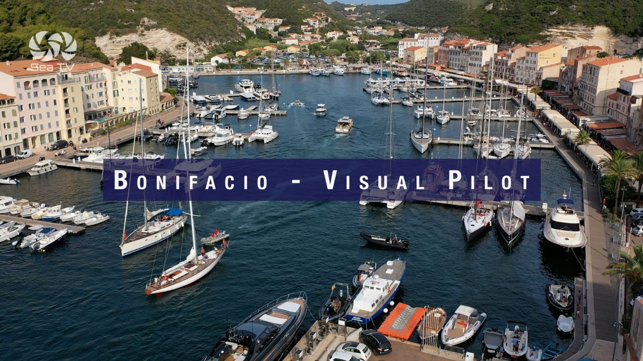
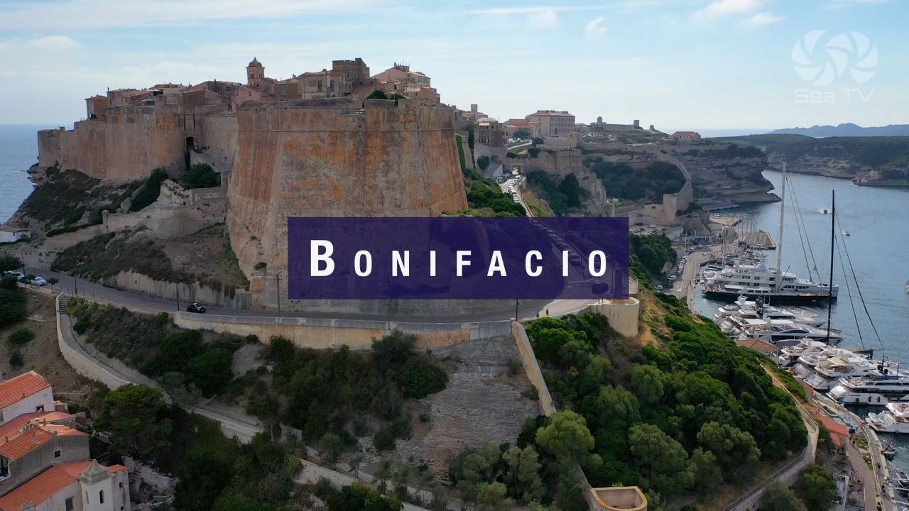
| Bonifacio | S | The most dramatic marina on Corsica — fjord entry through the Goulet. 350 berths. Must book ahead July–Aug. Gateway to Lavezzi and Sardinia. |
| Porto Vecchio | SE | Modern marina, 600 berths. Lively town. Good provisioning. 20 nm from Bonifacio. |
| Propriano | SW | Golfe du Valinco. Well-sheltered. Good base for west coast exploration. |
| Ajaccio | W | Capital of Corsica. Large marina. Ferry hub to mainland. Napoleon’s birthplace. |
| Calvi | NW | 500 berths. Citadel, sandy beach. Good shelter except from S. Popular charter base. |
| Saint-Florent | N | Golfe de Saint-Florent. Gateway to the Desert des Agriates (Plage de Saleccia). |
| Bastia | NE | Main commercial port. Old port and Vieux Port both usable for yachts. |
️ Best Anchorages by Area
South Coast — Bocche di Bonifacio
The most popular and most dramatic anchorages in Corsica — all within easy reach of Bonifacio. The Réserve Naturelle des Bouches de Bonifacio protects the entire area: strict rules on anchoring, no Posidonia, patrol by zodiac. Crowded July–August; excellent in June and September.
| Anchorage | Coords | SeaTV Guide |
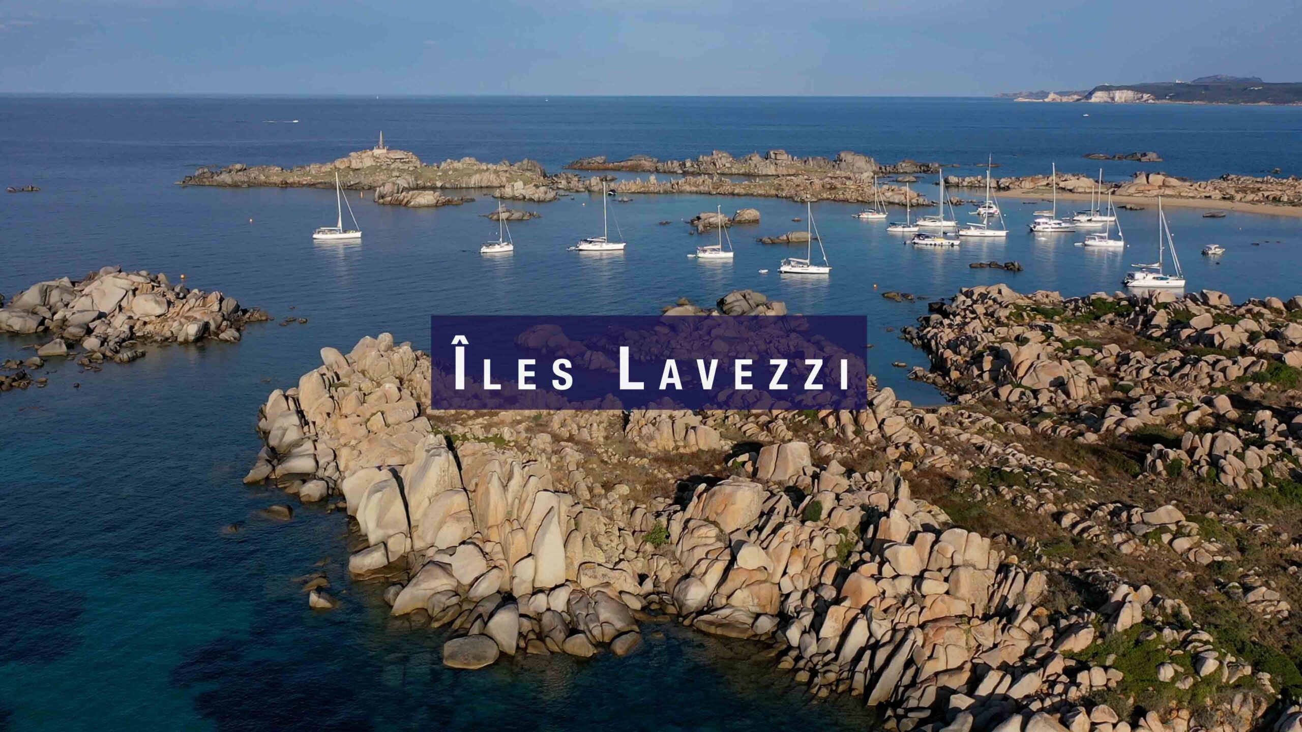
| Cala di U Grecu / Lavezzi | 41°20.528’N / 9°15.607’E | Îles Lavezzi Guide → |
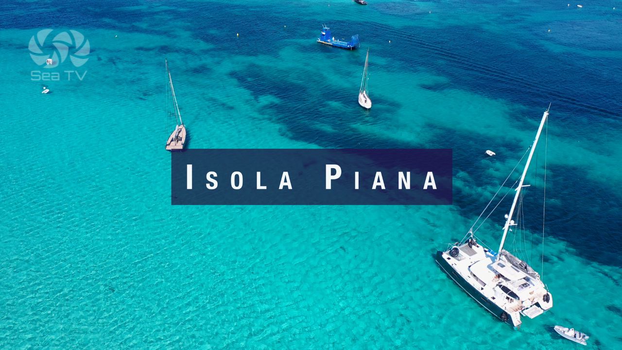
| Isola Piana / Plage du Petit Sperone | 41°22.50’N / 9°13.50’E | Isola Piana Guide → |
| Cala Lazarina (Lavezzi) | 41°20’20″N / 9°15’5″E | Part of Lavezzi group — see Lavezzi guide |
| Golfe de Pinarellu | 41°40’30″N / 9°22’39″E | SE coast. Sheltered bay, sandy beach, calm in most conditions. |
West Coast
The west coast of Corsica is spectacular but demanding — dramatic cliffs, limited shelter, and direct exposure to the Libeccio/Maestrale. The key anchorages are well worth the effort in settled conditions:
| Anchorage | Coords | Notes |
| Anse de la Figuera | 41°58’11″N / 8°38’2″E | SW coast. Sheltered cove in calm conditions. Day stop only in unsettled weather. |
| Golfe de Girolata | 42°21’8″N / 8°35’47″E | Réserve de Scandola. No road access — only by sea. One of the most spectacular bays in Corsica. Mooring buoys. UNESCO World Heritage. |
| Porto / Golfe de Porto | ~42°16’N / 8°42’E | Red porphyry cliffs. Small harbour. Réserve de Scandola day trips. Watch for afternoon westerlies. |
North & Northeast
| Anchorage | Coords | Notes |
| Plage de Saleccia | 42°43’43″N / 9°12’18″E | Desert des Agriates. White sand lagoon, completely wild. Accessible only by sea or 4WD. One of the finest beaches in France. Open to N winds. |
| Golfe de Saint-Florent | ~42°41’N / 9°18’E | Gateway to the Agriates coast. Well-sheltered marina. Pleasant town. |
| Baie de Calvi | ~42°34’N / 8°46’E | Citadel backdrop. Good shelter except from S. Sandy beach. Lively town. |
⚠️ Nature Reserves & Anchoring Rules
- Réserve Naturelle des Bouches de Bonifacio — Covers the entire south coast anchorage area including Lavezzi, Piana, Sperone. No Posidonia anchoring. Patrols by zodiac. Visitor quotas on Île Lavezzu may apply in high season. Check current OEC regulations before arriving.
- Réserve Naturelle de Scandola — UNESCO World Heritage. West coast, Golfe de Girolata area. Strict anchoring rules, mooring buoys only in most zones. No fishing. Zones fully closed to navigation. Check pnr-corse.fr for current rules.
- Posidonia anchoring — Prohibited throughout French waters under national decree. Heavy fines enforced. Use mooring buoys where available; anchor only on sand or rock.
- French anchoring decrees (Decree 156/2024) — Updated regulations apply to the entire south Corsica coast. Use the free app Nav & Co to identify current permitted zones and buoy locations.
- Île Lavezzu landing — Totally forbidden 15 December–15 April (bird nesting). Rest of year: marked paths only, no camping, no fire, no collecting.
- Isola Piana landing — Bird nesting: forbidden 15 December–15 April. Submarine pipeline north of island — no anchoring north of Piana.
️ Suggested Routes
| Route | Duration | Character |
| Bonifacio → Porto Vecchio → Golfe de Pinarellu → N | 7–10 days | South Corsica up the east coast. Sheltered, accessible, good for first-time Corsica sailors. |
| Bonifacio → Girolata → Calvi → Saint-Florent → Saleccia | 10–14 days | West and north coast circumnavigation. Exposed and spectacular. Requires good weather windows. |
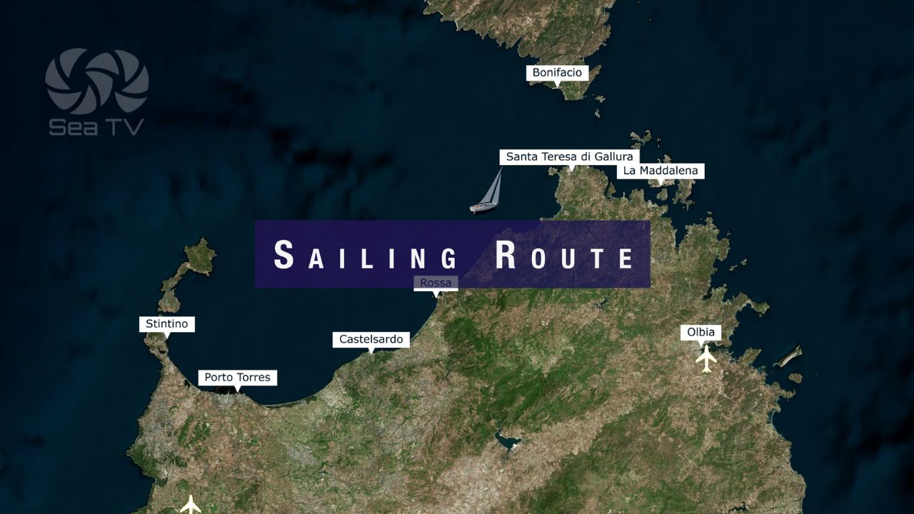
| Sardinia–Corsica combined circuit | 2–3 weeks | Both islands. La Maddalena Archipelago + Bonifacio + south Corsica anchorages. |
| SeaTV Sardinia–Corsica Route → | — | Full SeaTV recommended itinerary combining both islands. |
All SeaTV Guides — South Corsica
Bonifacio & Bocche di Bonifacio
- Marina Bonifacio — Goulet fjord entry. Katabatic wind. Citadel. Full marina guide.
- Bonifacio Town — Old town, Escalier du Roy d’Aragon, restaurants, history.
- Îles Lavezzi — French nature reserve. Cala di U Grecu. La Sémillante 1855 wreck. Daylight approach only.
- Isola Piana — Best breakfast anchorage. Two perfect beaches. Sandbank walk to Piantarella. Bird nesting rules.
La Maddalena Archipelago — Italian side (day-sail from Bonifacio)
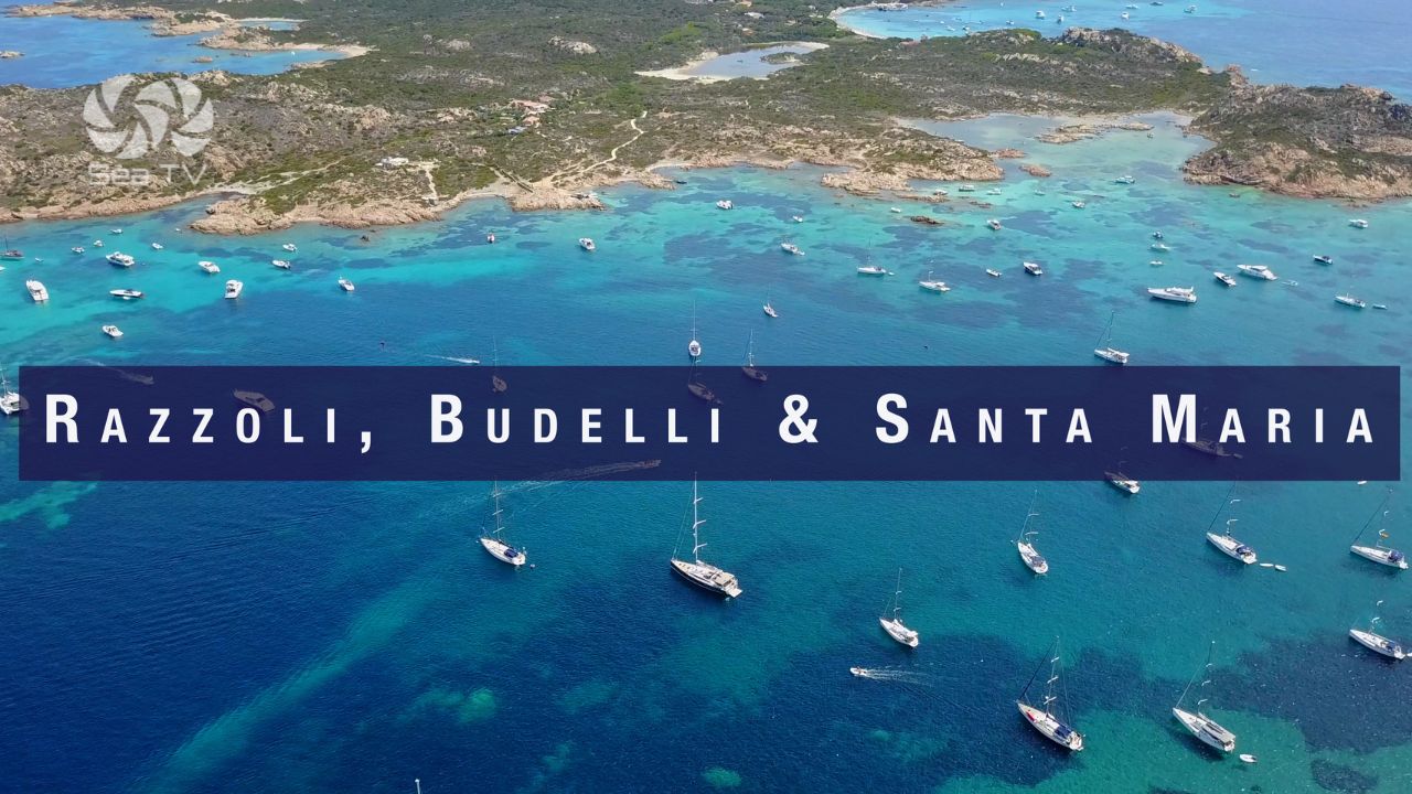
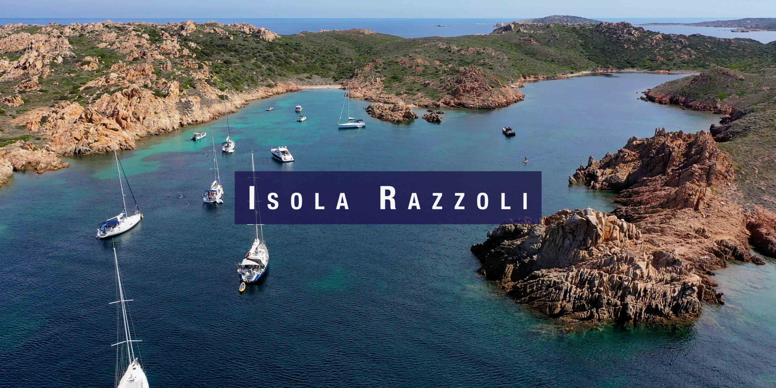
- Razzoli, Budelli & Santa Maria — Spiaggia del Cavaliere, Pink Beach rules, Chiesa di Morto shallow channel.
- Isola Razzoli — Cala Lunga — Remote, sheltered, granite. Rocks at entrance.
- Porto Pollo — Windsurf & kite paradise. Two bays. Maestrale funnel.
Practical Notes for Sailors
| Topic | Notes |
| Language | French. Corsican (Corsu) spoken alongside. Italian widely understood, especially in the south near Bonifacio. |
| Currency | Euro. Card accepted at most marinas. Carry cash for smaller anchorages and markets. |
| VHF | Monitor Ch. 16. Bonifacio port authority: Ch. 9. Sémaphores (French coastguard radio) on Ch. 16 — call before anchoring in reserve zones to confirm position. |
| Fuel | Available at Bonifacio, Porto Vecchio, Ajaccio, Calvi, Saint-Florent, Bastia. Plan ahead on the west coast — fuel stops are limited. |
| Water | All marinas. Limited at anchorages — carry adequate reserves, especially on west coast passages. |
| Anchoring app | Nav & Co (free) — shows current French anchoring decree zones and mooring buoy locations for Corsica and the south coast. |
| Weather | Météo-France Marine bulletin (VHF Ch. 79/80 south Corsica), Windy, PredictWind. Check every morning. The Bocche di Bonifacio can change within the hour. |
Sailor’s tip — Bonifacio as a base: The most efficient way to explore south Corsica is to base at Bonifacio marina and make day trips to Lavezzi, Isola Piana, and the Sardinian side of the Bocche. Depart at first light (06:30–07:00), reach the anchorage before the excursion boats (09:00), swim and explore, and return to Bonifacio by midday before the afternoon Maestrale builds. Two or three day trips like this, combined with evenings in the citadel, covers the entire south coast experience.